

Similarities Abound: A Meteorological Comparison Of The Arnett, OK and Greensburg, KS Tornadoes of 2007 & 2025
Similar presentations and similar synoptic setup yielding similar results

History doesn’t repeat itself, but often does rhyme. This statement is far from mutually exclusive to meteorology, but in the case of two similar looking tornadoes occuring in similar locations years later, the statement applies.
The May 18th, 2025 tornadoes near Arnett, Oklahoma and Greensburg, Kansas shared a similar look and occurred close to the same towns 18 years prior. Looking at the radar presentations gave me a sense of déjà vu. Fortunately, Greensburg was not hit by a violent tornado this time.
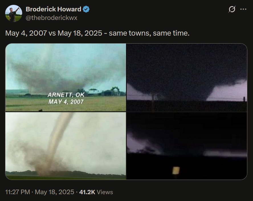
The picture above illustrates what I mean. Both supercells from 2007 and 2025 weakened after producing the Arnett tornadoes as they tracked to the northeast. In both years, another stronger supercell formed in southern Kansas, which both became strong tornado producers that lasted into the night.
The Event Of May 4th, 2007
Visuals sometimes tell stories best, so to start, I’ll link to Reed Timmer’s video of the video of Ellis County, Oklahoma tornado of May 4th, 2007 (near Arnett, OK). This will be used as a comparison to the 2025 tornado below.
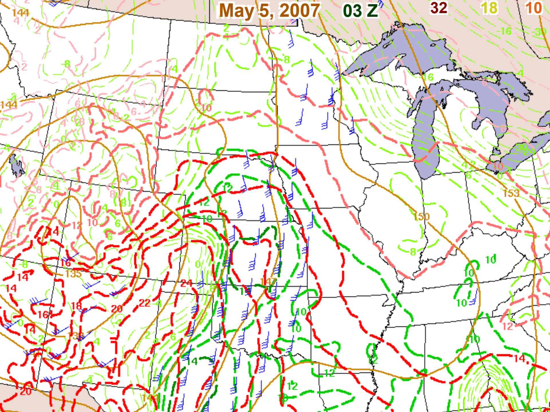
This would be the first tornado of interest to form on a day that had a moderate risk up for west central Kansas. Strong capping (discussed further below) prevented storms from exploding to life in an otherwise very conducive environment for strong tornadoes, with the exception of this one storm that produced this violent drill bit tornado.
This tornado did not last long and the parent supercell weakened as it headed north into Kansas. After dark, around 9 pm CST, the supercell took advantage of an environment that would better support its strengthening; stronger wind shear at all levels as the main trough moved east, the arrival of an upper level jet streak into western Kansas, better moisture being pulled north (weakening Convective Inhibition, or capping) and a retreating dryline to the west that featured a notable storm initiation point: a dryline bulge.
All factors helped kick start a weak, meandering supercell into one of the most prolific tornado families documented.
These are the tornado tracks after the event was surveyed days later. It’s incredible to think that Greensburg, an EF5, two mile wide tornado, may not have been the strongest tornado that came from the supercell, as the Troutsdale tornado was 2.5 miles wide and had velocity readings at similar levels as Greensburg.

I’ll link you to the wiki of the Greensburg event if you want to read more on this specific event. In short, 95% of the town was destroyed, but the town rebuilt as a “green town” as part of their recovery. I have personally visited Greensburg and have visited the Big Well Museum (I still use the keychain I bought there on my car keys).
The Event Of May 18th, 2025
If you compare the Ellis County tornado from 2007 to that of 2025, the tornado’s presentation at the 6:30 point in the video looks remarkably similar. Both were skinny, violent drill bit tornadoes that did not last too long and both parent supercells battled convective inhibition (capping concerns) throughout their lifecycles.
Similar to the 2007 event, this would be the first tornado of interest to form on a day that also had a moderate risk up for west central Kansas. Once again, capping delayed storms from erupting in a very conducive environment for strong supercells and tornadoes, with the exception of Arnett, again.
Following the pattern of 2007, the parent supercell weakened as it headed northeast into Kansas. The hypothesis for this weakening was an advancing dryline that initiated the supercell, but eventually squeezed it between dry air behind it and cool, stable air from the ongoing cloud cover that lingered throughout the day further east (tornado area marked in blue). Note the very low lapse rates (blue contours in OK and KS) which give you the indication of where the cloud cover was.

In the same region as 2007, south of Greensburg, the synoptic setup was similar: the supercell took advantage of stronger wind shear at all levels as the main trough moved east, the arrival of an upper level jet streak into western Kansas, better moisture being pulled north (weakening capping and better temperature/dew point spreads) and a stalled dryline.
What resulted was a prolific tornado producing supercell, but unlike 2007 (thankfully), no towns were destroyed. The radar presentation gave many observers Greensburg flashbacks when they saw it, I’m sure. The storm did go on to damage homes near the town of Plevna, Kansas as it continued, but as of last check, only minor injuries have been reported.
Unofficial damage assessments have given EF3 ratings to the tornadoes that passed south and east of Greensburg and to the Plevna, Kansas tornado. Two of these were a mile wide. They are subject to change as further assessments are done.
Meteorology Comparisons Between The Two Events: Upper Levels
Both events had sustained, multi-day troughing with multiple shortwaves (I discussed how the larger scale troughing will have multiple shortwaves embedded in the flow here for the 2025 event) and this was similar to 2007.
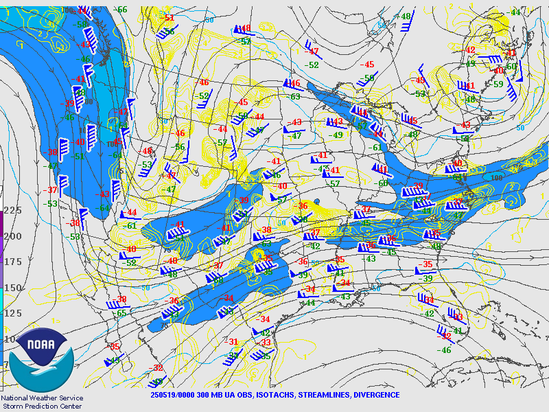
Upper levels both showed strong, back loaded, upper level jets, with the nose of the 300 mb jet streak entering western Kansas around 00z. The strongest upper level support coincided with the strengthening of the storms, in both years, when those storms began tracking to the north from Oklahoma. The 300 mb jets actually align quite closely.
Interesting note: both events may have been considered “day before the day” events. The day following these events were the ones that were of greater concern because of the second shortwave trough set to hit the following day. You can see the strong jet streaks over Washington state in both pictures below. May 5th, 2007, was a high risk day that produced over 100 tornado reports. May 19th, 2025, luckily, upscaled quickly and did not reach its projected peak.
Near Surface & Dryline
A pronounced dryline advance likely kicked off both 2007 and 2025 storms in Oklahoma. A dryline bulge, an area where a part of the dryline speeds ahead faster than the rest, was far more pronounced in the 2007 case in southwest Kansas.
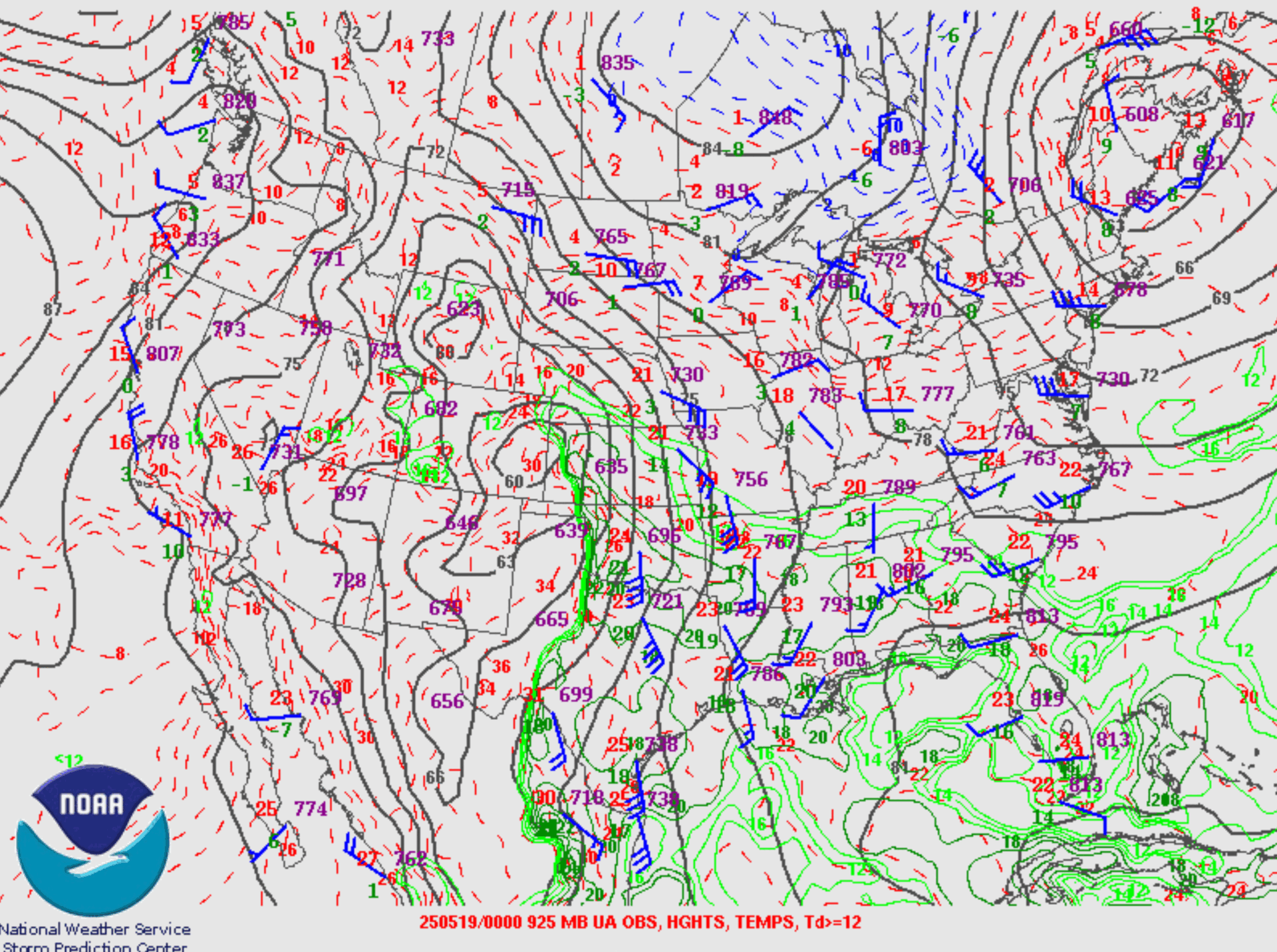
Both near surface lows were centered around southeastern Colorado and allowed for a steady stream of moisture (high dew points) to advance to the northwest from the Gulf of Mexico. Both events had at least mid 60°F dew points in the area after dark. Surface low alignment isn’t as close as the upper level jet, but still reasonable. The dryline is also close in alignment.
Surface Energy
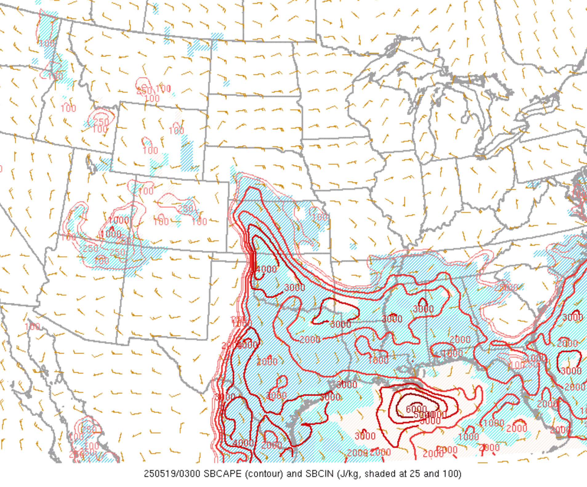
Both environments had high SBCAPE (low level energy, allowing for strong, sustained updrafts), but 2025 dealt with persistent cloud cover to the east, covering eastern Kansas and central Oklahoma, which limited the parameter space of the overall event.
If not for this stubborn cloud cover, it’s quite possible the event may have been more prolific in the warm sector further east into central OK/KS. Early Convection Allowing Models (CAMs) hinted at this until they caught on to the stubborn clouds. This cloud coverage likely played a role in limiting the strength and duration of the Arnett supercell of 2025. Note below that 2007 had a much wider warm sector. It’s a good thing it largely went unused.
Stronger capping in 2007 led to less overall storm coverage. Besides both events producing a tornado near Arnett, OK, the 2007 event had a few brief tornado and hail reports into Colorado and Nebraska. Both Arnett storms struggled to maintain themselves in the long term due to either warmer air aloft or stable air at the surface, but otherwise very favorable dynamics allowed for tornado formation early on.
Low Level Jet
Both events already had a strong low level jet in place in the afternoon (around 21z or 4 pm CST, but continued to intensify as the surface low deepened to the northwest as the night went on. Additionally, better moisture was transported to the north, and in the process, helped erode CIN (capping).
I had a hard time finding a sounding for the 2007 event, but will use the one of the May 18th event below. While of course each event is distinct, the intensifying low level jet is responsible for the incredible low level looping hodograph. Storm Relative Helicity was reaching extraordinary levels as a result (>570 m2s2). Even if the inversion around 850 mb mitigated some of this SRH from being utilized by the supercell (keeping in mind the Dodge City sounding below may show a more pronounced inversion than the Greensburg area encountered), it clearly was not enough to prevent strong tornadoes from occurring in 2025 or 2007; even if parameters were slightly different in 2007’s case.

Differences In Storm Coverage
In the storm event GIF near the beginning of the post, you may have noticed that more tornadoes formed in Texas in 2025 vs none in 2007. You also may have noticed more storms formed in west central Kansas in 2025 vs 2007.
In Kansas, this was due to less CIN (capping) and a pronounced dryline reaching into northeast Colorado as a focus for storm initiation. In fact, it had all but eroded in the area by the time tornadoes were ongoing near Grinnell, Kansas in the afternoon. The 2007 event featured a similar dryline placement, but stronger capping that even an advancing dryline could not breach until later in the night.
In Texas, this was, in part, due to the strong subtropical jet that passed over central Texas throughout the day. This served as a separate source of shear for storm organization and was absent in the 2007 event. Similar to Oklahoma, a strong low level jet, moisture transport, and high available surface energy allowed for a potent environment for supercells in north central Texas. A dryline bulge in central Texas was the source of storm initiation into this environment. The result was this tornado.
Overall, I was surprised to see two distinct events, 18 years apart, produce two different tornadoes, one in Oklahoma & one in Kansas, that hit nearly the same areas, looked similar, and shared enough similarities in the synoptic setup that I felt it worth writing about. While there were differences (they’ll never be perfectly aligned), this was rather close to an analogue to 5/4/2007 as you can get, and the results seemed to reflect that.