The Common Synoptic Traits Of Ice Storms & The Ice Storm Risk From March 29th Through The 31st
I'll explain common synoptic ice storm patterns and the risk for this coming weekend's storm.
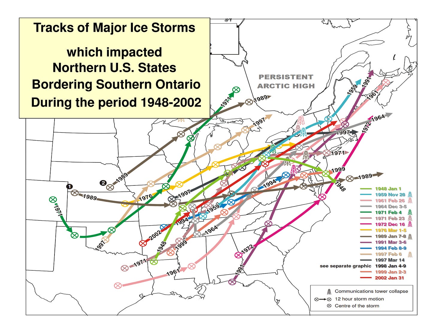
The Great Lakes & the northeast are no stranger to ice storms despite the most severe ones being relatively uncommon occurrences. Southern Ontario usually sees freezing rain a few times per year on more complex winter synoptic setups; even if it’s only a small part of the event’s precipitation and won’t get its own Wiki page. This is partly due to the northeast being a prime confluence zone for air masses to conflict, and when the synoptic pattern timing aligns, it can lead to notable ice accumulations. Of course, it isn’t just these regions that get ice storms. Cold air damming east of the Appalachians and arctic air mass intrusions into the US midwest meeting Gulf moisture can lead to ice storm tracks like you see below.

The Ice Storm of 1998, a generational ice storm that crippled parts of the northeast under incredible amounts of ice (100 mm+ in parts of eastern Ontario), is an example of a worst case ice storm scenario. I was still in elementary school when this event hit, but I distinctly remember seeing the event covered on TV and seeing hydro crews from my area heading to Quebec.
Traditional Ice Storm Synoptic Setup
Though not all setups are created equal, they commonly share patterns. It is common to find similar synoptic features associated with the major events. Let’s take the ice storm of December 20th, 2013 as an example:
You will often find a stationary boundary in place — an area where warm and cold air masses meet and remain in place for an extended period of time — and the duration of this stalled frontal boundary often impacts the severity of the event. Take note of the temperatures north of the boundary being at, or below freezing and temperatures being well above freezing just below it. Also note the southerly flow in the warm region and northerly to northeasterly flow in the cold region. We’ll explain this further in a minute.
You will find an area of high pressure (a ridge) to the north of this boundary (traditionally in Quebec, as you will see above). This ridging to north prevents quick low pressure ejections towards the northeast (they slow down) and often influences short wave troughs (low pressure systems) that come from the southwest to take a track along the boundary to the east, prolonging precipitation. The ridge provides a continuous supply of cold air at the surface that comes from the north — due to the clockwise flow of air around the ridge. You can see the ridge to the north, the stationary boundary and the precipitation from two distinct lows (ice is pink, blue is snow) taking shape below.
You will see either another ridge to the southeast near the Atlantic, which keeps warm, moist flow heading towards the boundary to the north and/or a notable troughing pattern across the US that allows for both moisture to be ejected towards the northeast from the Gulf, and for a convoy of low pressures embedded in the flow to make their way towards the northeast; leading to multiple rounds of freezing rain as long as the stationary boundary remains in place. Take note of the moisture (green contours) and general flow (wind barbs pointing to the Great Lakes starting from Texas) helping set the stage for a prolonged ice storm.
Lastly, it isn’t enough that two different air masses meet and low pressure interacts with the temperature gradient. If it was, you’d hear of ice storms far more frequently everywhere this happens. What is the case, however, is when that warm, moist flow from the south overruns the more dense, cold air at the surface, it rises over the top of it.
Any convection that forms through this process, or encounters this setup as it moves east, melts in an above freezing layer, then falls as rain and freezes on below freezing objects in a thin layer of cold air at the surface. This is illustrated below in an example sounding. Basically, the layer of warm air aloft, and layer of cold air below it, are the keys to precipitation type. Their duration, and even fluctuations during the storm, determine the impact. This site also shows how ice pellets and snow look in SKEW-T form, so if you’re interested, click on the link.
The March 29th-31st Setup
While this incoming setup does fit many of the prerequisites above (ridging to the north and to the southeast, allowing for continued Gulf moisture push to the Great Lakes, & multiple low pressure systems one after another), it isn’t an exact analogue.
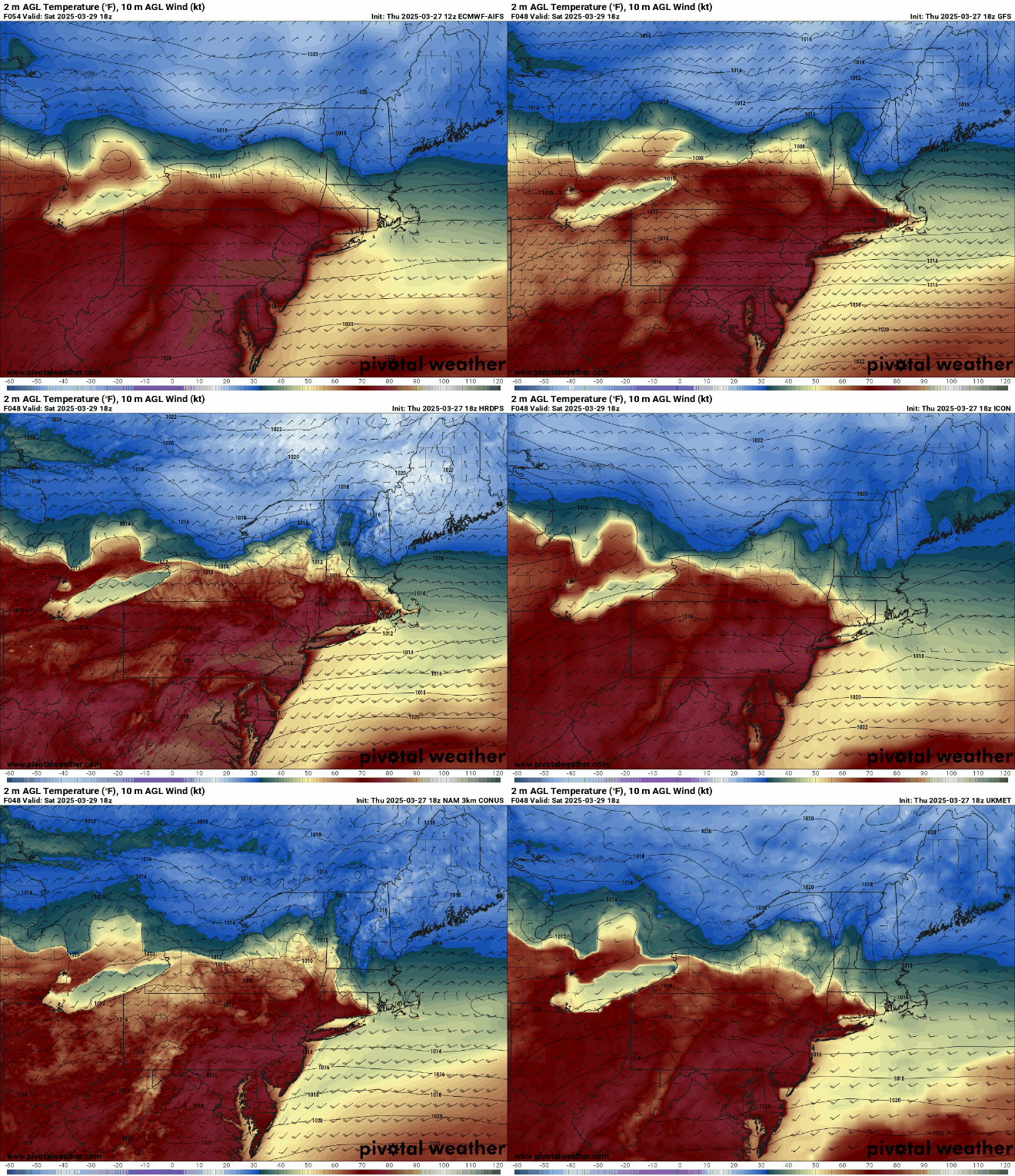
Northern ridging, the cold air source, looks to be at its strongest starting Saturday evening, instead of being entrenched ahead of time, meaning most of the Greater Toronto Area (GTA) will likely stay as rain as the first low comes into the area Friday night into Saturday morning. Cottage country, the 401 east, Kingston and eastern Ontario looks to be in more of the freezing rain risk zone beginning Friday night and into Saturday morning. Take note of the temperature gradient below for Saturday afternoon.

The second low, beginning Sunday morning and lasting throughout the day into Monday, will come in from the west and interact with the cold air from the ridge, which will be entrenched this time, meaning areas to the north and east of the GTA may see a long duration, several day freezing rain stretch. Take note of the consistency (not so much the quantities at this point) in the areas north of the GTA among models that reach this range (overnight Monday morning); showing an axis of high freezing rain and the inconsistency to the south of this axis.
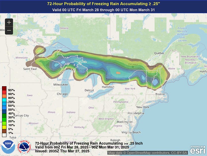
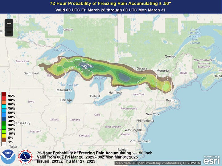
To reinforce the above point, you’ll note the one consistent area, with high probabilites of seeing greater than 0.25 and 0.50 inches of freezing rain 72 hours out (as far as the model goes as of now), lands in the Peterborough through Kingston area. Models are showing the surface temperature gradient, and warm nose aloft, setting up here for the longest freezing rain duration. Note that the lowest expected accretion, 0.1 inches, does include the GTA and Hamilton in it, with that modeled to happen on Sunday as the colder surface temperatures reach the area with a warm nose at 850 mb being in place.


Convection allowing models (CAMs) coming into view in a day or so should make things more interesting to analyze.
Key Questions
As you’d expect for ice related storms, there is still plenty model inconsistency when it comes to resolving the interaction of warm advection from the south vs cold air from the north, but this is the key to the entire event. This is unlikely to resolve clearly until the day of, if at all (I’ve seen enough of these events to avoid being surprised at models being off on the day). You can see this inconsistency for Sunday afternoon temperatures below.
Stronger than modeled warm advection and/or weaker than advertised ridging to the north means quicker low pressure ejection to the east, lesser quantities of ice accumulating, and warmer air pushing the warm front further north and away from the highest population regions of Southern Ontario, which has been the recent model trend.
A continually fluctuating temperature gradient will mean less predictable precipitation types, whereas a more constant zone location (like in the December 2023 GIF above) means one particular area will see prolonged freezing rain. This is the other key question: will a consistent zone set up or will it shift?
One last point: freezing rain setups, especially ones threatening long durations, are among the most difficult to forecast for the above reason. Even a change of degree or two along a small spatial area can change the precipitation type entirely and steady temperatures are never guaranteed for the duration of an event. Many projected ice storms for this area have ended up as ice pellets or rain only. In addition, most freezing rain model outputs are based on perfect levels of ice accretion, when only a percentage of that will actually stick.
In summary, if you’re in much of the northeast, just be aware of the potential for a notable freezing rain risk (or at least some form of ice) this coming weekend. Or prepare for rain if the warm sector shoots far into the north.


