
Anomalously Strong Ridging & Upcoming Multi-Day Severe Risk For Southern Ontario. The Week of August 22nd to 25th.
The Ring Of Fire Obliges

Last week, I talked about this week being one full of many interesting meteorological events. From Hurricane Hilary, Tropical Storm Harold, to an anomalously strong ridge in the midwest (happening now), to continuous mid/upper level flow over the Great Lakes for much of the week (happening now) that may open the door for severe weather - there’s lots around to observe. Pattern recognition is key in meteorology and patterns like this always get my attention.
I can talk about the now-becoming-active Atlantic in another post. In this one, we’ll discuss the current pattern across North America and what you can expect with a bit of a local bias towards Southern Ontario (which may end up seeing the strongest of this week’s pattern of storms, anyway).
Synoptic Pattern


The pattern hasn’t changed much from my article last week. I did not feel comfortable (I never do) giving anything beyond pattern recognition five + days out and an evaluation of whether model consensus + ensembles show agreement; given how models can struggle with intensity and duration of anomalous ridges. Last week, they showed agreement in this pattern occuring and they were on the ball. Now is the test to see how they handle both strength/duration of the ridge and the Ring of Fire severe risk.
In the images above, the strong ridge (high pressure) is very easy to find even if you don’t know much about meteorology. It is devoid of any mid level winds, and is centered near the midpoint of the US. The left image shows the degree to which how rare this ridge is when compared to the 1981-2010 climatology dataset and confirmed by the image in the middle last night, when the 500 mb levels reached a measure of 600 dam (the basics: that’s pushing record territory for that time/region. It’s a very strong ridge). The image on the right shows us what I’ll be leading into with regards to severe weather; mid and upper level flow (mid-level flow at 500 mb in this case) established over the Great Lakes. Wednesday night and Thursday night carry a severe risk for Southern Ontario, but the same question stands from last week, however: a question of energy.
I still have the following two questions, which we’ll discuss further below:
1) The degree of available energy. What is the spatial coverage - is it limited to SW ON? Is it a more broad coverage area?
2) Is the energy that arrives (before or after dark) surface based or mostly elevated?
If this sounds like an echo, this has been 2023 in Ontario’s calling card. What will the incoming shortwave have to work with when it arrives.
Timing & Threats: Wednesday


Starting tomorrow (Wednesday the 23rd [left] and Thursday the 24th [right]), parts of Southern Ontario can expect what looks like at least two disturbances, back to back, riding the established northwest flow that will be around until the weekend. With belts of at least 40+ kts of 200 mb, 500 mb, and 700 mb flow throughout Thursday night in the region, shear will be plentiful. Storms that form in this environment, that have energy to take advantage of, will be well organized even if they are more of an amalgamation, which seems to be the trend at the moment.
Wednesday morning (above, near London) should begin with large sections of Southern Ontario receiving rain and perhaps some elevated thunderstorms. You can see the 85 kt+ upper level jet and 50+ kt near 500 mb mid level jet, as well as nearly 700 J/kg of MUCAPE aloft, so a loud morning for some won’t be much of a surprise (depending on extent of energy aloft and how well ongoing storms hold up heading into the region), but it’s Wednesday evening that’s of particular note.


Take a look at projected SBCAPE (surface energy) just after sundown on Wednesday night. Little SBCAPE is expected into anywhere other than extreme SW Ontario, but large, looping hodographs are present and, most importantly, very large amounts of MUCAPE aloft covers a much larger area across Southern Ontario. Storms that are able to tap into this elevated energy will bring torrential downpours, frequent lightning and perhaps even large hail after dark. In comparison to above, in the gif below, even if the NAM is overdoing the extent of it, the trend is clear: MUCAPE is both greater in quantity and extent of coverage. Storms that go off, or are already ongoing, will have plenty to work with - energy wise - if these trends are true.

We have seen many case studies of events similar to this where SBCAPE reaches further than expected into Southern Ontario than projected on strong advection patterns; especially if morning convection clears out quick enough or avoids some areas outright, which would likely be the Windsor/London corridor on Wednesday. This means that both ongoing convection and shortwave timing will heavily influence the risk later in the night.
(Bonus point: In fact, it’s usually the inverse in Ontario: mid-tier events that don’t usually reach their “potential” are the ones with ongoing convection well into the afternoon and wrecking boundary layer energy. With a projection of very high elevated energy with a wider spatial coverage (MUCAPE across much of Southern Ontario), the likelihood of a nothing event is reduced; especially further to the SW.
Timing & Threats: Thursday

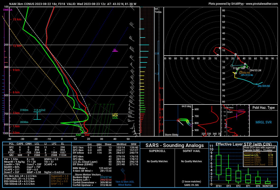
Thursday is more of a traditional setup and arguably has the higher ceiling for stronger storms. An uncommon EML ejection (elevated mixed layer, note the inversion between 700 and 850mb where the red line juts back to the right) into Southern Ontario is being forcasted among a few models now.
Both the shear orientation and magnitude don’t change much from Wednesday, so I won’t dive too deeply into that aspect. Thursday brings in a second disturbance, following the first, with a potentially stronger parameter set (especially in terms of surface energy - SBCAPE) to work with. The inversion in place will likely hold off initiation until the later afternoon hours and it gets a bit messy from there - as is the usual trend for these synoptic setups with plentiful energy.
Some runs have storms upscaling and turning into a strong linear risk rather quickly, whereas others have the environment staying capped off until after dark entirely. Both the strength of the inversion, how quickly it erodes (if it does) + the extent and magnitude of Wednesday’s storms will also influence the environment (especially at the surface) before Thursday, so other than stating:
the shear in place will be similar to that of Wednesday (potent)
the SBCAPE will likely be higher across much of Southern Ontario & MUCAPE will be similar (plentiful)
an EML will hold off early initiation and potentially prime (or disrupt) the late afternoon/night for a severe risk…
…I will hold off on breaking Thursday’s risk down further than this. I will revisit it Wednesday night or Thursday morning. The risk of severe weather, and if SBCAPE is plentiful, all severe risk options are on the table; including tornadoes.
Through Thursday Night

One last aspect to note: although there isn’t quite a consensus among model QPF expectations, there is a concern for localized flash flooding. Since models haven’t (and likely won’t) come to a consensus on storm path and intensity, following the broader trend of stronger forcing and established NW flow means the risk for training storms. Even if storms are elevated and not surfaced based, steady, ongoing rainfall following the same path still opens the door to this risk. The above is only one deterministic model, so don’t take this as definitive, but other deterministic models have shown similar and shifted peak QPF locations elsewhere. It’s something to be aware of.
That’s it for Tuesday night’s analysis. I’ll update if I see any major changes.